Features
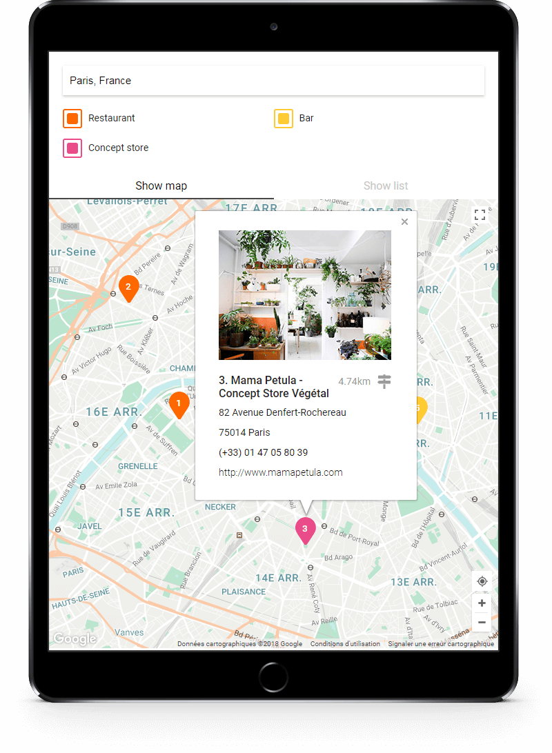
Responsive design
Storelocatorjs is responsive mobile first and can be customized with just a few CSS rules.


Maps styles
The map can be customized with a configuration object in the map.options.styles property. Use for example Snazzy Maps tools to generate a JSON configuration, and paste it in the constructor key map.options.styles.
Below, an example of configuration:
| {
"styles": [{"featureType":"administrative","elementType":"labels.text.fill","stylers":[{"color":"#6195a0"}]},{"featureType":"administrative.province","elementType":"geometry.stroke","stylers":[{"visibility":"off"}]},{"featureType":"landscape","elementType":"geometry","stylers":[{"lightness":"0"},{"saturation":"0"},{"color":"#f5f5f2"},{"gamma":"1"}]},{"featureType":"landscape.man_made","elementType":"all","stylers":[{"lightness":"-3"},{"gamma":"1.00"}]},{"featureType":"landscape.natural.terrain","elementType":"all","stylers":[{"visibility":"off"}]},{"featureType":"poi","elementType":"all","stylers":[{"visibility":"off"}]},{"featureType":"poi.park","elementType":"geometry.fill","stylers":[{"color":"#bae5ce"},{"visibility":"on"}]},{"featureType":"road","elementType":"all","stylers":[{"saturation":-100},{"lightness":45},{"visibility":"simplified"}]},{"featureType":"road.highway","elementType":"all","stylers":[{"visibility":"simplified"}]},{"featureType":"road.highway","elementType":"geometry.fill","stylers":[{"color":"#fac9a9"},{"visibility":"simplified"}]},{"featureType":"road.highway","elementType":"labels.text","stylers":[{"color":"#4e4e4e"}]},{"featureType":"road.arterial","elementType":"labels.text.fill","stylers":[{"color":"#787878"}]},{"featureType":"road.arterial","elementType":"labels.icon","stylers":[{"visibility":"off"}]},{"featureType":"transit","elementType":"all","stylers":[{"visibility":"simplified"}]},{"featureType":"transit.station.airport","elementType":"labels.icon","stylers":[{"hue":"#0a00ff"},{"saturation":"-77"},{"gamma":"0.57"},{"lightness":"0"}]},{"featureType":"transit.station.rail","elementType":"labels.text.fill","stylers":[{"color":"#43321e"}]},{"featureType":"transit.station.rail","elementType":"labels.icon","stylers":[{"hue":"#ff6c00"},{"lightness":"4"},{"gamma":"0.75"},{"saturation":"-68"}]},{"featureType":"water","elementType":"all","stylers":[{"color":"#eaf6f8"},{"visibility":"on"}]},{"featureType":"water","elementType":"geometry.fill","stylers":[{"color":"#c7eced"}]},{"featureType":"water","elementType":"labels.text.fill","stylers":[{"lightness":"-49"},{"saturation":"-53"},{"gamma":"0.79"}]
}
|
Autocomplete
Storelocatorjs includes by default Google Maps Autocomplete. The places librairy is automatically loaded.
Geolocation
Storelocatorjs integrate its own geolocation button .storelocator-geolocButton to trigger a geolocation request.
Geolocation need SSL certificat with https on Google Chrome and somes others recents browsers. Documentation is available on Google Developers.
Filters
Storelocatorjs can be used with or without filters. Filters let you filter stores by categories. Store categories can be unlimited but must be unique for each marker. Identifie them by a unique ID in the JSON key categories as string format.
Marker styles
Marker have a default style, the same as on Google Maps. Storelocatorjs has an option to easily customized the style of the marker with a pretty SVG.
To use this feature, fill the option map.markers as below:
1
2
3
4
5
6
7
8
9
10
11
12
13
14
15
16
17
18
19
20
21
22
23
24
25
26
27
28
29
30 | {
"map": {
"markers": {
"width": 30,
"height": 40,
"styles": [
{
"category": "userPosition",
"colorBackground": "#4285f4",
"colorText": "#fff"
},
{
"category": "1",
"colorBackground": "#ec4233",
"colorText": "#fff"
},
{
"category": "2",
"colorBackground": "#009925",
"colorText": "#fff"
},
{
"category": "3",
"colorBackground": "#eeb211",
"colorText": "#fff"
}
]
}
}
}
|
You can change marker dimensions (width and height) in pixel by passing an integer (without unity).
map.markers.style contains object and each objects correspond to a marker category, with 3 parameters:
The marker category userPosition allow you to customized the marker style of the user geolocation. Do not change the category name of this marker.
Internet Explorer doesn't accept custom SVG for markers. Default markers are use on this browser.
Clusters
With cluster option enabled, you need to load the markerclusterer.js library before the storelocatorjs. Documentation is available on Google Developers
| <script src="https://developers.google.com/maps/documentation/javascript/examples/markerclusterer/markerclusterer.js"></script>
|
 1
 2
 3
 4
 5
 6
 7
 8
 9
10
11
12
13
14
15
16
17 | new storelocatorjs({
options: {
cluster: {
status: true,
options: {
gridSize: 50,
maxZoom: 13,
imagePath:
'https://developers.google.com/maps/documentation/javascript/examples/markerclusterer/m',
zoomOnClick: true,
averageCenter: true,
minimumClusterSize: 2,
styles: []
}
}
}
});
|
Default image can be changed, fill the option cluster.options.styles as below, to easily customized the style of the cluster image.
 1
 2
 3
 4
 5
 6
 7
 8
 9
10
11
12
13
14
15
16 | new storelocatorjs({
options: {
cluster: {
options: {
styles: [
{
url: '/images/cluster.png',
textColor: '#000',
width: 60,
height: 60
}
]
}
}
}
});
|
Markers update
Storelocatorjs auto-search allow to refresh markers on area bounds changed. Zoom or move events may trigger an auto-search if user extends the area. To use this feature, enable options markersUpdate.status.
Enable debug option to see viewport overlays above the map:
red: list of all stores according to maxRadius option. User can move on this area without refresh the map.green: list of all stores according to the limitInViewport option. Map is centered on this viewport.
Info window
Storelocatorjs allow to show marker informations with the native Google Maps info window. Below, the default template displays the fields available in the JSON.
 1
 2
 3
 4
 5
 6
 7
 8
 9
10
11
12
13
14
15
16
17
18
19
20
21
22
23
24
25
26 | <div class="storelocator-infoWindow">
<span class="store-picture">
<img src="{picture}" alt="{title}" />
</span>
<div class="storelocator-detailStore">
<span class="storelocator-detailStoreTitle">{title}</span>
<span class="storelocator-detailStoreDistance">
<a
href="http://www.google.fr/maps/dir/${origin}/${destination}"
title="Itinerary"
target="_blank"
>
{distance}km
</a>
</span>
<span class="storelocator-detailStoreAddress">{address}</span>
<span class="storelocator-detailStoreZipcode">{zipcode}</span>
<span class="storelocator-detailStoreCity">{city}</span>
<span class="storelocator-detailStorePhone">
<a href="tel:{phone}" title="Call">{phone}</a>
</span>
<span class="store-link">
<a href="{link}" title="Visit website" target="_blank">{link}</a>
</span>
</div>
</div>
|
You will notice that the distance information is automatically caculate with the cloud function script 👍.

